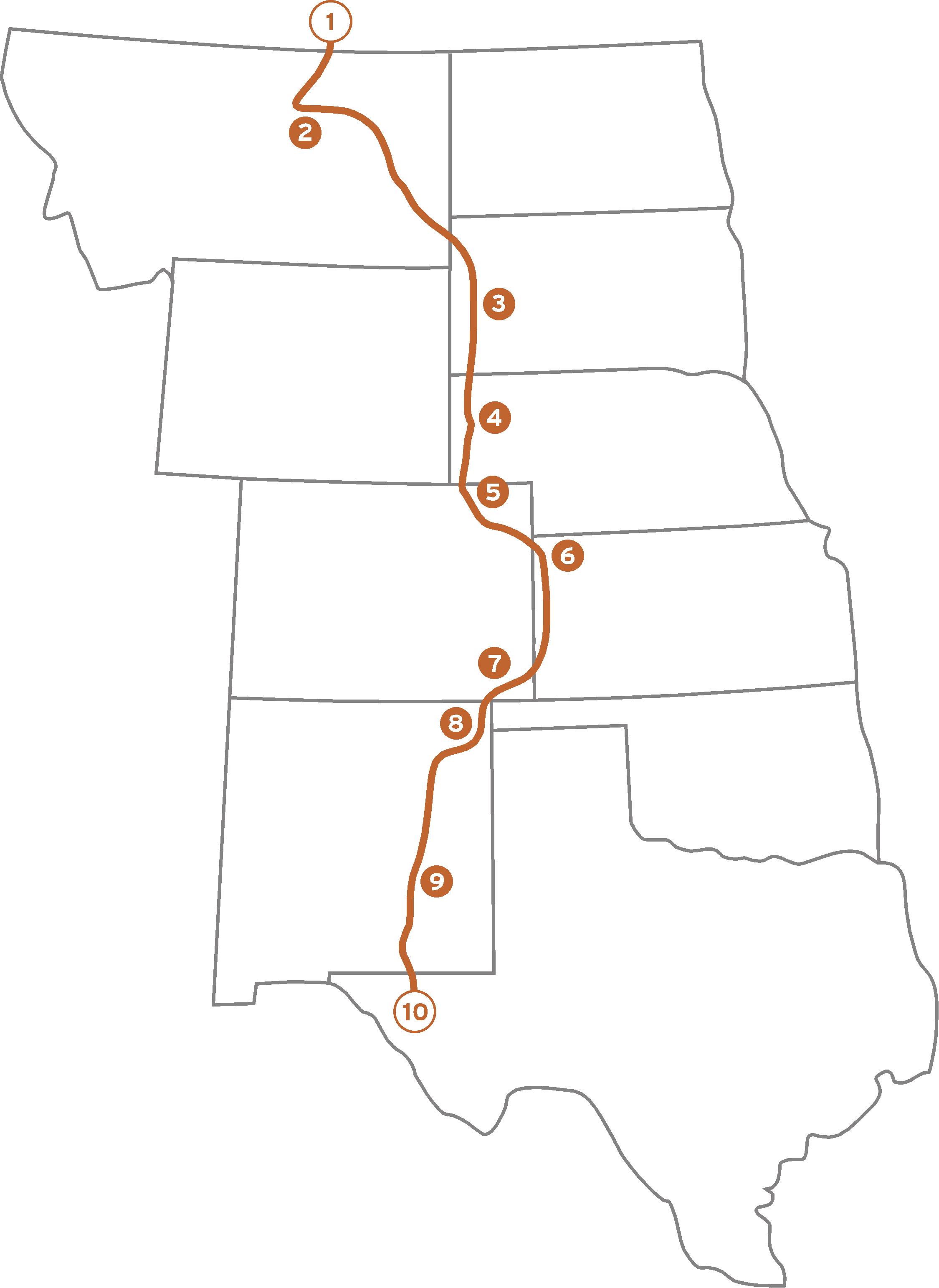
A few weeks ago I mentioned some highlights of the Great Plains Trail. I am very excited to now provide a map which gives a rough idea of where I think the trail should be. Of course, this is far from the only option, but I think it represents some of the best things the plains have to offer and takes advantage of the widely scattered public lands that exist.
Here is a look at the map:
 Below is a brief description of the numbered highlights of the trail.
- The northern terminus of the Great Plains Trail (GPT) is on the U.S./Canada border adjacent to the western section of Canada’s Grasslands National Park.
- The GPT will pass through the 3,000,000+ acre American Prairie Reserve as well as the Charles M. Russell National Wildlife Refuge in eastern Montana.
- The GPT will take advantage of the forests and views provided by The Black Hills of South Dakota.
- Western Nebraska is dotted with pine forests, buttes, and badlands as well as the famous Scotts Bluff National Monument.
- The GPT bisects the visually dramatic Pawnee National Grassland in eastern Colorado.
- The GPT swings into western Kansas to view the stunning canyons of the Arikaree Breaks.
- Comanche National Grassland in southeastern Colorado contains abundant wildlife, an impressive canyon system, and ancient dinosaur tracks.
- The GPT will follow the Santa Fe National Historic Trail through parts of Kiowa National Grassland in northern New Mexico.
- The GPT will drift far enough west to catch glimpses of 10,000+ foot peaks in eastern New Mexico.
- The southern terminus for the GPT is high atop the summit of Guadalupe Peak, the highest point in Texas, in Guadalupe Mountains National Park.
All told, the trail is probably in the neighborhood of 1,500 miles. Of course, the Great Plains does not stop at the Canadian border. Extending it into Canada would be fantastic! Perhaps into the subtle, but inviting Cypress Hills Interprovincial Park in Alberta and Saskatchewan.
Wherever the trail goes, to journey along it will be a worthwhile endeavor – be it 1,500 miles, or 15 minutes. Adventure awaits.


6 Responses
Thanks for the map. Now the trail seems even more tangible.
It’s a great route; almost like “The Great Plains Greatest Hits.”
It’ll be fun to start seeing maps that show sections as they’re completed and in-progress.
Thanks for the encouragement! I’m starting simply, but at least it provides a visual for the scope of the idea.
Hey Steve,
When you get a chance, you may want to look at the 4/30/11 post on the trailsnet blog. It’s got some information about the GPT and the American Discovery Trail. I hope you don’t mind that I added an image of your map (above) in that post. If that’s a problem, please let me know, & I’ll remove it.
Not a problem at all. Thanks for doing that! I’ll check it out.
A grand plan! Anything happening with it? Saw this on the National Parks Traveler a while back.
Thanks for your interest in the GPT Cathryn! There are a lot of things in the works right now that will be coming to fruition in fairly short order. Stay tuned!