
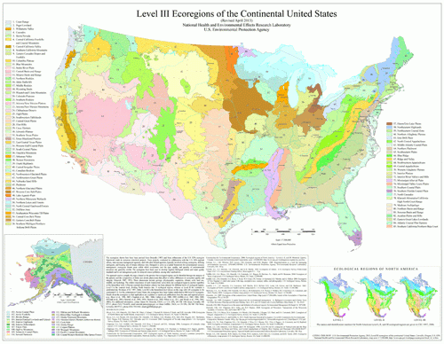
 We’re breaking it down now for Level III to just the Continental United States. The entire continent gets too complicated when the finer points start to emerge within the broader regions.
Here is a link to the PDF Map: Level III MAP
I’m really enjoying these maps! Let’s look at the Level III regions that the Great Plains Trail traverses in numerical order:
#17 The Middle Rockies – The Black Hills are a part of this ecoregion.
#23 Arizona/New Mexico Mountains – Guadalupe Mountains National Park fits this ecoregion.
#24 Chihuahuan Deserts – Extreme southern New Mexico is in this region.
#25 High Plains – That seems fitting. This area exists in parts of Texas, New Mexico, Oklahoma, Kansas, Colorado, Nebraska, Wyoming, and South Dakota.
#26 Southwestern Tablelands – The GPT crosses this region in New Mexico, Oklahoma, and Colorado.
#42 Northwestern Glaciated Plains – These can be found in South Dakota, North Dakota, and Montana.
#43 Northwestern Great Plains – The home states here are North Dakota, South Dakota, Montana, Wyoming, and a little bit in Nebraska.
#46 Northern Glaciated Plains – If the GPT ends in North Dakota instead of Montana, the GPT will also cross this ecoregion, which exists in North Dakota, South Dakota, and Minnesota.
That’s as many as eight Level III ecoregions highlighting the enormous diversity of the Great Plains!
One Response
Great maps!!! They highlight what we already know… the Great Plains are incredibly diverse and beautiful!!